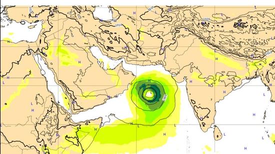
First cyclone of 2021 likely to form over Arabian Sea on May 16
This will be the first cyclone of this year and will be called Tauktae meaning gecko (named by Myanmar).
The first cyclonic storm of the year could be brewing as a low-pressure area is very likely to form over the southeast Arabian Sea around May 14 morning that is likely to intensify gradually into a cyclonic storm over the east-central Arabian Sea around May 16, and continue to move north-northwestwards, the IMD has said.

“There is a lot of variation among models. Some models are showing it’s likely to cross the Oman coast, some indicate south Pakistan which would also mean parts of Gujarat will be affected,” said Sunitha Devi, in charge, cyclones at India Meteorological Department.
This will be the first cyclone of this year and will be called Tauktae meaning gecko (named by Myanmar) when formed. There is a chance that the cyclone may cross the north Gujarat or Kutch area on May 20.
“We can indicate landfall only once the low-pressure area forms. The message now is mainly to ensure fishermen on the west coast come back by May 14 because the sea will be rough. We are expecting severe weather and heavy rainfall around Lakshadweep, Kerala, coastal Karnataka, ghat areas of Tamil Nadu and parts of Maharashtra following the formation of low-pressure areas,” added Devi.
Normally one or two cyclones form over the North India Ocean during the pre-monsoon season in April and May. This time no cyclone formed in April but a depression had formed over the south Andaman Sea last month.
“The conditions are prime, with warm waters and an active Madden Julian Oscillation (fading though) that could support cyclogenesis. Will the Arabian Sea see its first cyclone of the year (Tauktae)?” tweeted Roxy Mathew Koll, a climate scientist at the Indian Institute of Tropical Meteorology (IITM), Pune.
The Madden Julian Oscillation (MJO) is characterised by a band of rain clouds moving across the tropics, depending on their location they can assist cyclone build up, he explained.
The low-pressure area is very likely to move north-northwestwards across the southeast Arabian Sea and adjoining the Lakshadweep area and intensify gradually. It may intensify into a Cyclonic Storm over the east central Arabian Sea around May 16 and continue to move north-northwestwards, the IMD said in a statement on Tuesday.
Light to moderate rainfall at most places over Lakshadweep with heavy falls at isolated places on May 13 and heavy to very heavy falls at isolated places very likely on May 14. Light to moderate rainfall at most places with heavy to very heavy falls at isolated places is very likely over Kerala, Karnataka and Tamil Nadu on May 14 and 15.
Squally weather with wind speed reaching 40-50 kmph gusting to 60 kmph is very likely over southeast Arabian Sea and adjoining Lakshadweep – Maldives area and the equatorial Indian Ocean from May 14 morning. It is very likely to increase gradually, becoming 50-60 kmph gusting to 70 kmph over the same region from May 15 morning. It’s likely to intensify to gale wind speed reaching 60–70 kmph gusting to 80 kmph over east-central Arabian Sea and adjoining southeast Arabian Sea and Lakshadweep area from May 16 morning.
Squally wind speed reaching 40-50 kmph gusting to 60 kmph likely along and off Kerala coast on May 14 and 45-55 kmph gusting to 65 kmph along and off Kerala - Karnataka coasts on May 15 and 16. Squally wind speed reaching 40-50 kmph gusting to 60 kmph is also likely to prevail over Comorin Maldives area during May 14-15. Squally wind speed reaching 40-50 kmph gusting to 60 kmph is very likely to prevail along and off Maharashtra-Goa coasts on May 16.
Sea condition over east central Arabian Sea will be very rough to high (6-9 metres wave height/34-47 mts) on May 16. Sea conditions will be rough to very rough over Comorin area and along and off the Kerala coast on May 14 and 15 and over the east-central Arabian Sea along and off Karnataka coast on May 15 and Maharashtra–Goa coasts on May 16.
Fishermen are advised not to venture into the southeast Arabian Sea, Lakshadweep – Maldives areas, Kerala – Karnataka coasts from May 14 and into the east central Arabian Sea and along and off Maharashtra – Goa coasts from May 15.
Get Current Updates on India News, Lok Sabha election 2024 live, Election 2024 along with Latest News and Top Headlines from India and around the world.


